The Gas Map Gets Sharper. Does the Response Get Faster?
Denser fixed gas-sensor networks sharpen the spatial picture of a release, but that picture only cuts time-to-safe-response if alarm routing and response ownership improve with it, otherwise a denser map is just a better record of what already went wrong.
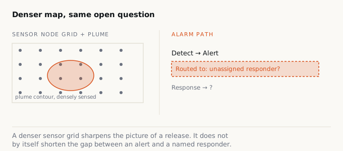
Picture a process area with forty fixed gas sensors instead of four. The control room screen shows a live contour map: concentration gradients, a plume edge creeping toward a walkway, a timestamp ticking up. It looks like the site finally knows what its air is doing. In one narrow sense, it does. The open question is whether anyone downstream of that screen is faster to get someone out of the way.
What density actually buys you
A handful of point detectors tells you a threshold was crossed somewhere in their reach. A dense, mapped network tells you where, roughly how much, and which direction it’s drifting. That’s a real gain in resolution, not a marketing gain. For confined-space and process-area work, spatial detail matters because the atmosphere doesn’t move uniformly, and knowing whether a release is drifting toward an occupied walkway or away from it is a materially different piece of information than a single alarm light.
OSHA’s Permit-Required Confined Spaces standard already assumes atmospheric conditions can be uneven and change while people are inside: it requires testing before entry and, in spaces where isolation isn’t feasible, continuous monitoring of the areas where authorized entrants are working rather than a single spot check. A denser sensor array is a plausible way to satisfy that intent with more fidelity than a lone handheld reading at the entry point. That’s the legitimate case for the network. It is also the entire case. The standard specifies that the atmosphere gets watched; it does not specify, and a sensor grid cannot supply, what happens between an alarm firing and a person reaching safety.
The map is not the plan
Here is where the falsifiable claim sits: spatial density improves the picture, but the picture only shortens time-to-safe-response if two things travel with it, a routing design that sends the alarm to a specific person who can act, and a clearly named owner of that response before the alarm ever fires. Neither is a sensor problem. Both are design problems that predate the network and don’t get solved by adding more nodes to it.
This is close to settled territory in process-control alarm management, just not always imported into site safety thinking. The ANSI/ISA-18.2 standard on management of alarm systems for the process industries treats alarm rationalization, deciding which signals justify an alarm, who receives it, and what response it demands, as a distinct lifecycle stage from detection itself. The standard’s premise is that a control system generating more data points does not automatically generate better operator response; response quality is a function of how alarms are prioritized, routed, and acted on, which is a work-process question, not an instrumentation question. Swap “control room operator” for “confined-space attendant” or “area supervisor” and the same premise holds for a gas-sensor map.
Monday-morning check
Pick one fixed gas sensor on your site map at random and ask: when this alarm fires, which specific named person's phone, radio, or console lights up, and what are they trained to do in the next sixty seconds? If the honest answer is "the control room sees it" with no named responder and no defined action, **does adding forty more sensors to that same routing design actually get anyone to safety faster, or does it just log the event in higher resolution?**
Reading a signal is not the same as knowing what to do with it
Even where routing works and an alarm reaches the right console, the plotted data still has to be interpreted correctly under pressure. NIOSH’s 2022 advisory on multi-gas monitor use, aimed at firefighters responding to natural gas and propane incidents, is specific on this point: readings can behave differently on scene than they did during calibration, and responders need training to interpret what a given reading means for hazard status, not just to note that a threshold was crossed. A denser spatial map compounds that same interpretation burden. More nodes means more simultaneous readings to reconcile into one judgment about where it’s safe to stand, and a plume contour that looks clean on a dashboard can still be wrong if sensor spacing, wind, or ventilation patterns weren’t accounted for in how the map was built. Density adds information. It doesn’t add judgment, and it doesn’t add the training time it takes to build that judgment in the people watching the screen.
The test that would actually prove it
The spine here is straightforward: don’t let a detailed picture stand in for a fast response. The honest way to find out which one you’ve built is to measure it. Before expanding a fixed network, or right after, track actual time from alarm trigger to a named responder’s first action, not to acknowledgment on a screen, on the same handful of real or drilled release scenarios. If that interval doesn’t shrink after the upgrade, the density bought a sharper after-action report and nothing else. That’s not a failure of the sensors. It’s a sign the money went into resolution when it needed to go into routing and ownership first.
None of this argues against denser coverage. Confined spaces and process areas with uneven airflow are exactly where a better spatial picture earns its keep. But the picture is a diagnostic tool, not a response system, and a site that can’t currently say who answers a single alarm won’t fix that by having more alarms to not answer. Build the routing and the named ownership first. The map gets to be as dense as the budget allows once that part actually works.